|
Rezatec was formed in 2012 to help businesses better manage their land-based assets by making use of the increasingly sophisticated but complex array of Earth Observation (EO) imagery and data available. We do this through our unique landscape intelligence platform aggregating large amounts of diverse data from satellites, airborne and ground instruments, applying relevant modelling and using our mapping, measuring and monitoring techniques with best-in-class technology to provide critical decision support for our customers. Customers today are spread across the Agribusiness, Biofuels, Energy, Water, Forestry and FMCG sectors. Headquartered within the Harwell Space Cluster, Oxfordshire, UK, Rezatec's staff have backgrounds in software development, forest and agricultural management, EO methods and tools and advanced computing techniques. ProcessBuild, Enrich & Analyse Rezatec's unique approach to deriving high-value landscape intelligence products and ongoing services can be described in three key steps: 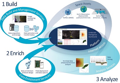 Build
Enrich
Analyze
 | |
|
OUR ROLE IN BACI RZT’s role in BACI takes places within WP2. The key role of RZT is in providing the mechanism to combine the data (which would already be on CEMS) and putting it in a unified format and then applying providing an algorithm prototype code for its implementation and getting it up and running. It will act as a scalable access stream to support biodiversity indicators looking for novel ways of using data. | |
|
KEY PEOPLE
Links | |
BACI: 2015-2019
TOWARDS A BIOSPHERE ATMOSPHERE CHANGE INDEX

